When you click on links to various merchants on this site and make a purchase, this can result in this site earning a commission. Affiliate programs and affiliations include, but are not limited to, the eBay Partner Network.
GLACIER PEAK SUIATTLE RIVER WASHINGTON VINTAGE USGS TOPO MAP 1901 TOPOGRAPHIC VintageCartographics Original USGS Topo Maps 1901 / 1946
Glacier Peak
Washington
USGS TOPOGRAPHIC MAP
1946 print in good condition
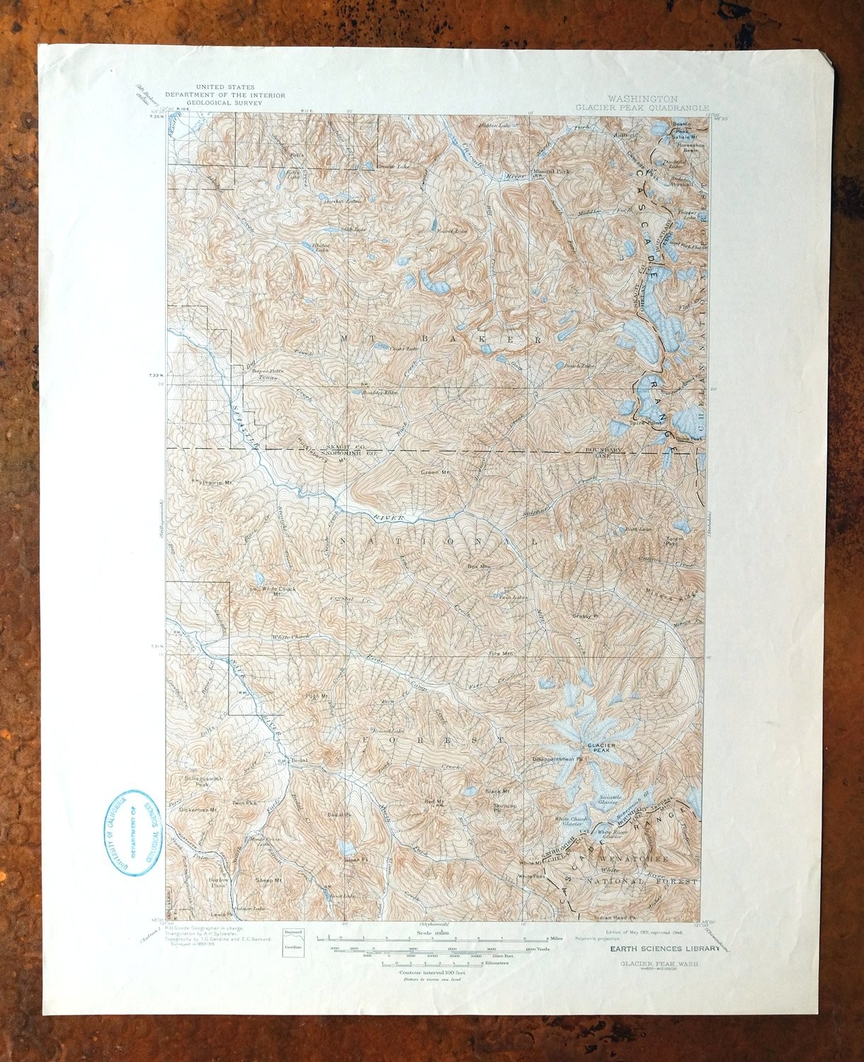
For sale is the 1901 edition of the Glacier Peak 30-minute map. This map would be great for framing or display, historical reference or research, genealogy studies, adding to a collection, treasure hunting, a nice conversation piece, a gift for a history or map enthusiast, or for anyone interested in this area.
This sheet includes the only survey produced by the United States Geological Survey for the Glacier Peak 30-minute quadrangle. The map sheet is an original 1946 USGS print in good condition.
The Glacier Peak 30-minute map shows roads, paths, towns, railroads, rivers, creeks, elevation contour lines, public land survey lines, county, state, and other administrative boundaries, and many structures (houses, churches, schools, barns, etc.) as they existed at the time of the survey in 1897 through 1899.
The Glacier Peak map was field surveyed before aerial photography methods were widely used in map data gathering. It was drawn by cartographers based on plane table field survey information as well as information gathered from local residents in the area. It displays the remarkable abilities of early government map makers, who placed a strong emphasis on creating complete, accurate, and cartographically appealing maps.
Maps from the USGS 30-minute series have been out of print for many years. They have never been common and original prints are increasingly difficult to find. For areas where the 30-minute map was produced, it is usually the first large-scale survey done by the USGS for that area. These are a valuable historical record, as they contain many placenames and features that have been dropped from more recent series' and editions.
MAP DETAILS Title Glacier Peak State Washington Location North Cascades National Park, 65 miles northeast of Seattle Series 30-minute Surveyed 1897 through 1899 Field Survey Geographer R.U. Goode Edition 1901 Printed 1946 Print Notes Thick paper stock Scale 1:125000 Contour Interval 100 feet Sheet Dimensions 17 x 21 inches Map Dimensions 11 5/8 x 17 1/2 inches Coverage Area 23 x 35 miles SHEET CONDITION For maps of this vintage, effort is made to note all visible flaws, no matter how minor. Overall Condition GOOD Sheet Notes never folded Map Area no markings, no blemishes Collar Area no markings, minor blemishes, no edge tears, light handling in bottom collar, library stamp in collar MAP COVERAGE Quadrangle extent overlaid on current basemap. Browse Nearby
Sheets PLACENAMES Depending on map series and survey date, all of the features listed below may not be shown on this map. This list contains features that currently exist or historically existed within the area covered by the map. The list can be used as a reference to determine if this map covers your area of interest. Placenames are listed alphabetically next to each feature type. Counties Covered Chelan, Skagit, and Snohomish Federal Land Units Glacier Peak Wilderness, Henry M. Jackson Wilderness, Mount Baker National Forest, North Cascades National Park, Stephen Mather Wilderness, and Wenatchee National Forest Rivers and Streams All Creek, Amber Creek, Arrow Creek, Bachelor Creek, Baekos Creek, Barrett Creek, Basin Creek, Bath Creek, Bedal Creek, Bench Creek, Big Creek, Black Creek, Black Oak Creek, Bluebell Creek, Boston Creek, Boulder Creek, Bowser Creek, Brown Creek, Buck Creek, Cadet Creek, Camp Creek, Canyon Creek, Captain Creek, Cascade River, Chetwot Creek, Chikamin Creek, Chocolate Creek, Chocwich Creek, Circle Creek, Cleve Creek, Conn Creek, Conrad Creek, Cougar Creek, Crystal Creek, Dan Creek, Dead Duck Creek, Decline Creek, Dolly Creek, Dome Creek, Doubtful Creek, Downey Creek, Drop Creek, Dubor Creek, Dusty Creek, Dutch Creek, East Fork Milk Creek, Eldorado Creek, Elliott Creek, Falls Creek, Fern Creek, Fire Creek, Flat Creek, Foam Creek, Found Creek, Fourteenmile Creek, Gamma Creek, Gilbert Creek, Glacier Creek, Goat Creek, Goodman Creek, Grade Creek, Gravel Creek, Hard Creek, Harriet Creek, High Log Creek, Hilt Creek, Horse Creek, Illabot Creek, Indigo Creek, Irene Creek, Iron Creek, Jordan Creek, Jug Creek, Kennedy Creek, Kindy Creek, Lightning Creek, Lime Creek, Lost Creek, Marten Creek, Martin Creek, Meadow Creek, Merry Brook, Midas Creek, Middle Fork Cascade River, Milk Creek, Milt Creek, Miners Creek, Morning Star Creek, Mutchler Creek, North Fork Cascade River, North Fork Falls Creek, North Fork Sauk River, O'Brian Creek, Otter Creek, Owl Creek, Palmer Creek, Pearsall Creek, Peek-a-boo Creek, Pelton Creek, Perry Creek, Pincer Creek, Prairie Creek, Pugh Creek, Pumice Creek, Red Creek, Roush Creek, Ruby Creek, Salix Creek, Sauk River, Shake Creek, Sitkum Creek, Skagit River, Sloan Creek, Small Creek, Sonny Bay Creek, South Fork Cascade River, South Fork Falls Creek, South Fork Sauk River, South Fork Stillaguamish River, Spire Creek, Stehekin River, Straight Creek, Stujack Creek, Suiattle River, Sulphur Creek, Swamp Creek, Swift Creek, Tahlak Creek, Tenas Creek, Thunder Creek, Vee Creek, Vista Creek, Weeden Creek, West Fork Agnes Creek, West Fork Flat Creek, White Chuck River, White Creek, and White River Water Bodies Airplane Lake, Bath Lakes, Boulder Lake, Box Mountain Lakes, Buller Lake, Canyon Lake, Caskey Lake, Chaval Lake, Crystal Lake, Doubtful Lake, Emerald Lake, Foss Lake, Hidden Lake, Honeycomb Glacier, Indigo Lake, Jug Lake, Le Conte Lake, Lime Lake, Lake Louise, Marten Lake, Meadow Lake, Lake Metam, Mica Lake, Middle Cascade Glacier, Milk Lakes, Monte Cristo Lake, Lake Number 1, Prairie Mountain Lakes, Rivord Lake, Ruby Lake, Slide Lake, Snowking Lake, South Cascade Glacier, Sulphur Mountain Lake, Trapper Lake, Twin Lakes, Upper Falls Lake, Upper Jordan Lake, and Yang Yang Lakes
Locations: Canyon Creek Shelter, Bedal Campground, Buck Creek Campground, Chocwich Campground, Crystal Creek Campground, Dearinger Campground, Dolly Vista Shelter, Downey Creek Campground, Downy Trailhead, East Side Buck Creek Campground, Elliott Creek Camp, Hidden Lake Lookout, Huckleberry Lookout, Kennedy Hot Spring, Kennedy Hot Springs, Mackinaw Shelter, Mill Camp, Mineral Park Campground, Mineral Park Guard Station, Miners Creek Shelter, North Fork Guard Station, Orient, Owl Creek Campground, Red Mountain Lookout, Sixmile Shelter, Sloan Creek Campground, South Fork Camp, Suiattle Guard Station, Suiattle Trailhead, Sulphur Creek Campground, Twin Peaks Camp, Tyee Pool Camp, White Chuck Campground, White Chuck Trailhead, White Deer Camp, and Whitewater Launch. Mountains, Peaks, and Summits: Arts Knoll, Barlow Point, Box Mountain, Bedal Peak, Black Mountain, Boston Peak, Mount Buckindy, Cascade Peak, Mount Chaval, Circle Peak, Mount Dickerman, Disappointment Peak, Dome Peak, Downey Mountain, Mount Forgotten, Mount Formidable, Fire Mountain, Gamma Peak, Glacier Peak, Green Mountain, Horseshoe Peak, Huckleberry Mountain, Hurricane Peak, Hurry-up Peak, Illabot Peaks, Indian Head Peak, Johannesburg Mountain, Kennedy Peak, Le Conte Mountain, Lewis Peak, Lime Mountain, Lizard Mountain, Magic Mountain, Meadow Mountain, Mount (not official) Misch, Mix-up Peak, Morning Star Peak, Old Guard Peak, Painted Mountain, Pelton Peak, Portal Peak, Prairie Mountain, Mount Pugh, Razorback Mountain, Saddle Point, Sahale Mountain, Mount Saul, Sentinel Peak, Sheep Mountain, Sinister Peak, Skullcap Peak, Sloan Peak, Snowking Mountain, Spider Mountain, Spring Mountain, Stillaguamish Peak, Sulphur Mountain, Tenpeak Mountain, Trapper Mountain, The Triplets, Twin Peaks, White Chuck Cinder Cone, White Chuck Mountain, White Mountain, and Zi iob Peak. Valleys and Canyons: Box Canyon and Penders Canyon. Parks: Boston Glacier Research Natural Area, Henry M Jackson Wilderness, and Mineral Park. Trails: Glacier Ridge Trail, Kennedy Ridge Trail, and Meadow Mountain Trail. Drainages: All Creek, Amber Creek, Arrow Creek, Bachelor Creek, Baekos Creek, Barrett Creek, Basin Creek, Bath Creek, Big Creek, Bluebell Creek, Brown Creek, Cadet Creek, Camp Creek, Canyon Creek, Bedal Creek, Bench Creek, Black Creek, Black Oak Creek, Boston Creek, Bowser Creek, Buck Creek, Captain Creek, Chetwot Creek, Chikamin Creek, Chocolate Creek, Chocwich Creek, Circle Creek, Cleve Creek, Conn Creek, Conrad Creek, Cougar Creek, Crystal Creek, Dead Duck Creek, Dolly Creek, Dome Creek, Doubtful Creek, Downey Creek, Drop Creek, Dubor Creek, Dusty Creek, Dutch Creek, East Fork Milk Creek, Eldorado Creek, Elliott Creek, Foam Creek, Falls Creek, Fern Creek, Fire Creek, Found Creek, Fourteenmile Creek, Gamma Creek, Garnet Creek, Gilbert Creek, Glacier Creek, Goat Creek, Goodman Creek, Grade Creek, Hard Creek, Harriet Creek, Hidden Lake Creek, High Log Creek, Horse Creek, Indigo Creek, Iron Creek, Jug Creek, Kennedy Creek, Kindy Creek, Lightning Creek, Lime Creek, Lost Creek, Marten Creek, Martin Creek, Meadow Creek, Merry Brook, Midas Creek, Middle Fork Cascade River, Milk Creek, Milt Creek, Miners Creek, Morning Star Creek, Mutchler Creek, North Fork Cascade River, North Fork Falls Creek, North Fork Sauk River, O'Brian Creek, O'Brien Creek, Otter Creek, Owl Creek, Palmer Creek, Pearsall Creek, Peek-a-boo Creek, Pelton Creek, Pincer Creek, Pugh Creek, Pumice Creek, Red Creek, Roush Creek, Ruby Creek, Salix Creek, Shake Creek, Sitkum Creek, Skalabats Creek, Skull Creek, Sloan Creek, Small Creek, Soldier Boy Creek, Sonny Bay Creek, South Fork Cascade River, South Fork Falls Creek, South Fork Sauk River, Spire Creek, Straight Creek, Stujack Creek, Sulphur Creek, Swamp Creek, Swift Creek, Tahlak Creek, Tenas Creek, Thunder Creek, Triad Creek, Vee Creek, Vista Creek, Weeden Creek, and White Chuck River. Capes: Sahale Arm. Mines: Diamond Mine. Forests: Darrington Ranger District and Wenatchee National Forest. Lakes and Ponds: Airplane Lake, Arrowhead Lake, Basin Lake, Bath Lake, Bath Lakes, Bear Lake, Bluff Lake, Box Mountain Lakes, Lake Byrne, Cadet Lake, Camp Lake, Beaver Lake, Bee Lake, Bench Lake, Boulder Lake, Buller Lake, Chaval Lake, Cliff Lake, Cougar Lake, Crater Lake, Crystal Lake, Cub Lake, Cyclone Lake, Diamond Lake, Doubtful Lake, Downey Lake, Emerald Lake, Enjar Lake, Fly Lake, Falls Lake, Foss Lake, Found Lake, Found Lakes, Goat Lake, Goodman Lake, Granite Lakes, Hamar Lake, Hardtack Lake, Hidden Lake, Horse Lake, Hyas Lake, Ida Lake, Illabot Lake, Image Lake, Indigo Lake, Itswoot Lake, Jordan Lakes, Jug Lake, Lake Kawkawak, Kid Pond, King Lake, Kool-Aid Lake, Lake Toketie, Le Conte Lake, Lime Lake, Long Gone Lake, Lookout Lake, Lost Lake, Lake Louise, Lower Granite Lake, Lower Jordan Lake, Lower Jug Lake, Marten Lake, Meadow Lake, Lake Metam, Mica Lake, Milk Lake, Milk Lakes, Monte Cristo Lake, Mule Lake, Myrtle Lake, Nels Lake, Neori Lake, Lake Number 1, Lake Number 1, Lake Number 2, Lake Number 2, Pear Lake, Peek-a-boo Lake, Pelton Lake, Pemmican Lake, Pilot Lake, Prairie Mountain Lakes, Reflection Pond, Rivord Lake, Round Lake, Ruby Lake, Skaro Lake, Slide Lake, Slim Lake, Snowking Lake, Sonny Boy Lakes, South Cascade Lake, South Lake, Spire Lake, Sulphur Mountain Lake, Sunup Lake, Target Lake, Thornton Lake, Lake Toketie, Trapper Lake, Lake Tupso, Twin Lakes, Upper Falls Lake, Upper Granite Lake, Upper Jordan Lake, Van Lake, Whale Lake, White Chuck Lakes, White Rock Lakes, Woods Lake, and Yang Yang Lakes. Waterfalls: Gibson Falls, North Fork Falls, and Teepee Falls. Bluffs: Grassy Point, North Guardian Rock, and Spire Point. Gaps: Barlow Pass, Bettys Pass, Cache Col, Bingley Gap, Cascade Pass, Fire Creek Pass, Headlee Pass, Johannesburg Col, Kaiwhat Pass, Rat Trap Pass, Red Pass, Ross Pass, Stujack Pass, Totem Pass, and White Pass. Basins: Buckeye Basin, Horseshoe Basin, and Thunder Basin. Ridges: Gamma Ridge, Glacier Ridge, Grassy Point, Kennedy Ridge, Lime Ridge, Miners Ridge, Ripsaw Ridge, and Vista Ridge. Flats: Green Mountain Pasture. Pillars: North Guardian Rock and South Guardian Rock. Springs: Gamma Hot Springs and Sulphur Hot Springs.
SHIPPING AND RETURNS This map sheet will be carefully rolled in a sturdy tube and shipped via the US Postal Service.If you find that the sheet you receive is not as described in the listing, you may ship it back to us for a refund of the purchase price.
15~239 15~240 15~241 15~242 15~243 15~247 15~248 15~367 15~368 15~369 15~375 15~376 15~508 15~509 15~510 15~511 15~513 15~514 15~515 15~656 15~657 15~658 15~659 15~662 15~806 15~809 15~810 30~126 30~127 30~128 30~129 30~130 30~131 30~198 30~200 30~201 30~202 30~203 30~204 30~205 30~206 30~276 30~277 30~278 30~279 30~280 30~281 30~62 30~63 30~64 30~65 30~66 30~67 75~1017 75~1018 75~1019 75~1020 75~1021 75~1022 75~1023 75~1197 75~1198 75~1199 75~1265 75~1266 75~1267 75~1268 75~1269 75~1270 75~1271 75~1461 75~1462 75~1463 75~1528 75~1529 75~1530 75~1531 75~1532 75~1533 75~1534 75~1741 75~1742 75~1743 75~1802 75~1803 75~1804 75~1805 75~1806 75~1807 75~2026 75~2027 75~2028 75~2029 75~2087 75~2088 75~2089 75~2090 75~2091 75~2310 75~2311 75~2312 75~769 75~770 75~771 75~772 75~948 75~949 75~950 75~951