When you click on links to various merchants on this site and make a purchase, this can result in this site earning a commission. Affiliate programs and affiliations include, but are not limited to, the eBay Partner Network.
ALL OUR SHIPPING FROM UK TO USA IS NOW VIA ROYAL MAIL PDDP ( Postal Delivery Duties Paid ). THIS MEANS ANY IMPORT DUTY IS PAID BY SENDER. NO FURTHER DUTY PAYMENT IS REQUIRED BY THE RECIPIENT.
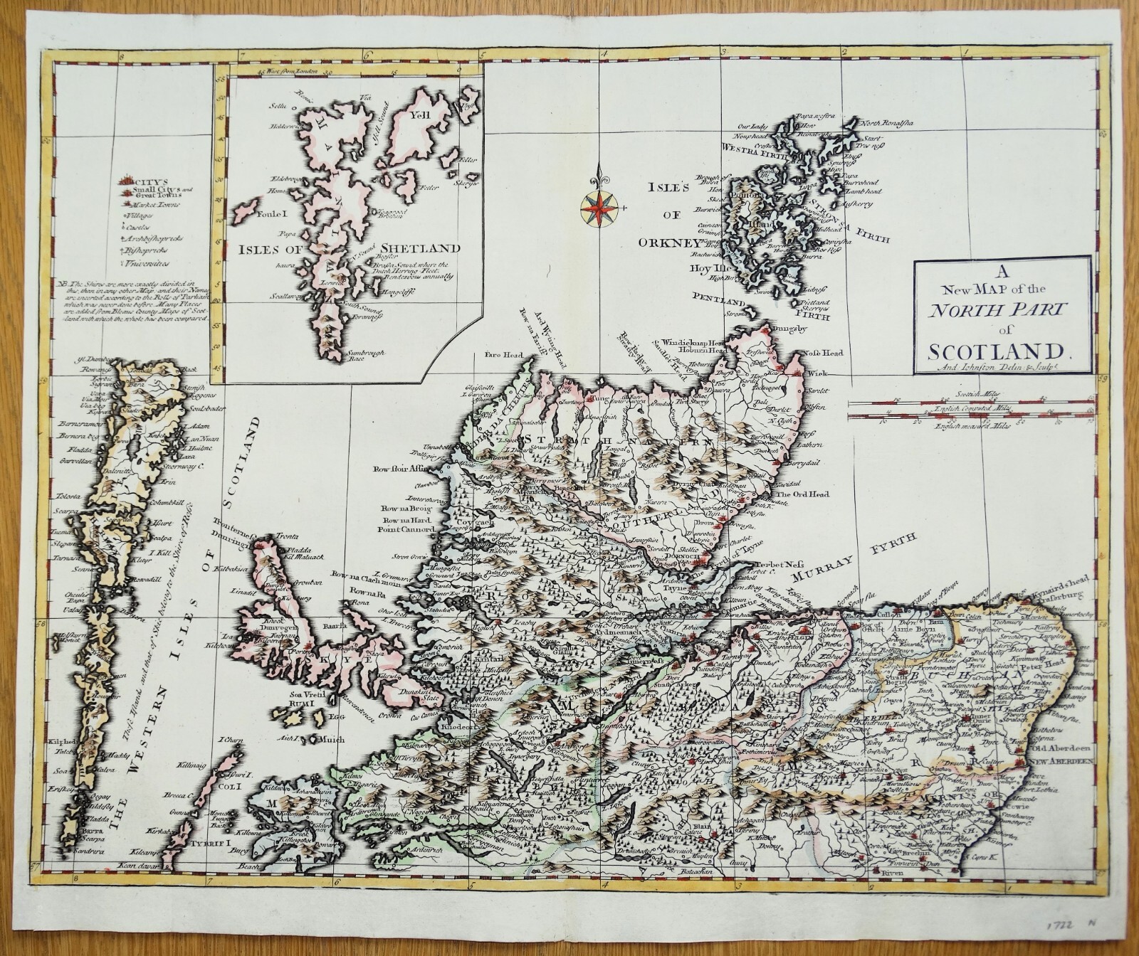
An Original Antique Map
A New Map of the
NORTH PART of
SCOTLAND
By Andrew Johnston
Drawn and engraved by Andrew Johnston although often attributed to Robert Morden, publishedinCamden\'s Britannia by Abel Swale, Awnsham and John Churchill, London 1722
A finecopper engraved original antique map of Northern Scotland. Morden\'s original map depicting Scotland as a whole, was replaced in the 1722 edition of Britannia by a pair of more detailed maps of the north and south parts, contributed by Andrew Johnston.
A highly detailed map covering Scotland from below Aberdeen to the Orkney Isles, with an inset map of Shetland.
An excellent example greatlyenhancedwithattractive later hand colouring.
Fine condition other than insignificant age related blemishes, free of repairs or restoration.
Centre fold as issued.
Approx. 16.5\" x14\" (420mm x 360mm)map area only, withgoodmargins beyond.
Printed onhand laid paper which remains stable and robust, blankverso.
Pleaseseealsoclose up images.
The \"GeographyRectified\" pocket worldatlas was Robert Morden\'searliestimportant work published in 1688with a few later editions up toc1700.His best known work however, was the series of English countymaps he produced to illustrate theEdmund Gibson editions of Camden\'sBritannia, published in 1695 and again in 1722, with several further rarereditions up to 1772. A series of smaller county maps were published in1701 and later. No extensive survey was carried out as such but the previous Saxton& Kip (or Hole) maps were updated by whatever information could be found.Morden also produced a variety of other cartographic works including globes,geographical playing cards and large scale maps, notably of London.
A GENUINEANTIQUE MAP GUARANTEED OVER 300 YEARS OLD FROM LINDISFARNE PRINTS
D824N