When you click on links to various merchants on this site and make a purchase, this can result in this site earning a commission. Affiliate programs and affiliations include, but are not limited to, the eBay Partner Network.
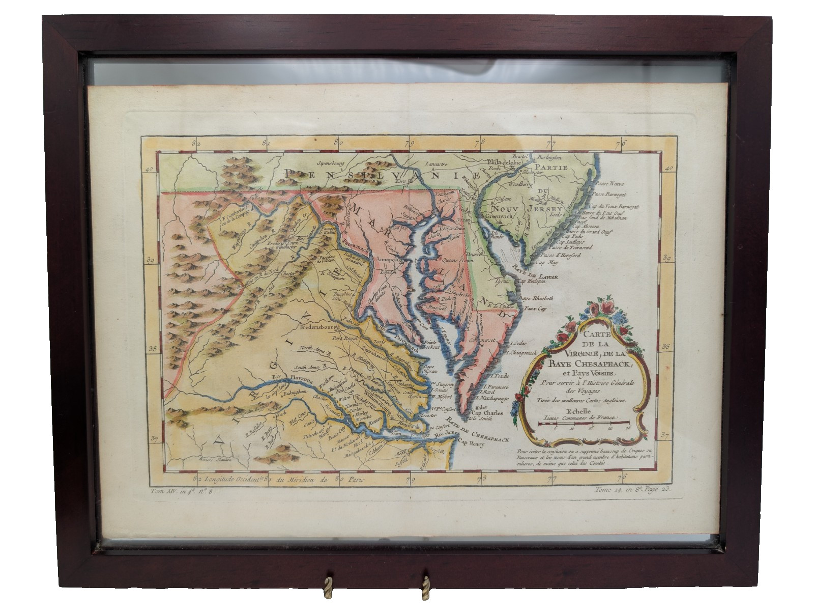
An exceptionally beautiful and historically significant 18th century French antique map of Virginia, Maryland, and the Chesapeake Bay region, engraved for one of the most celebrated geographical publications of the Enlightenment era.
The cartouche title reads in full: "Carte de la Virginie, de la Baye Chesapeack, et Pays Voisins / Pour servir à l'Histoire Générale des Voyages / Tirée des meilleures Cartes Angloises" — meaning "Map of Virginia, Chesapeake Bay, and Neighboring Countries / To serve the General History of Voyages / Drawn from the best English Maps."
The volume and plate references at the bottom — "Tom. XIV in 4°. N° 8" and "Tome 14 in 8°. Page 23" — identify this as Plate 8 from Volume XIV of Abbé Antoine-François Prévost's monumental "Histoire Générale des Voyages" (General History of Voyages), one of the defining geographical encyclopedias of 18th century France, published in multiple editions between approximately 1746 and the 1780s. Longitude is measured from the Paris meridian, confirming its French origin.
The map covers a geographically and historically rich area including:
- Virginia in full — with Williamsburg, Richmond (shown as "Richebond"), Fredericksburg, and the James, Rappahannock, Potomac, and York Rivers all charted in fine detail
- Maryland — with Annapolis clearly marked and the Patowmack (Potomac) River prominently featured
- Pennsylvania — upper border showing Philadelphia, Lancaster, and York
- New Jersey — with Cape May and Delaware Bay
- The entire Chesapeake Bay ("Baye de Chesapeack") in beautifully rendered blue watercolor wash
- Delaware coastline and bay features
- Ornamental hill/mountain hachures in the Appalachian region rendered in the period style
The cartouche is a masterwork of 18th century engraving — surrounded by a lavishly hand-colored floral garland of roses and blue flowers in the Rococo style, with gilt-yellow scrollwork frame. The color throughout is rich, vibrant, and appears to be entirely original period hand-coloring — pink for Maryland/Virginia territories, golden yellow for New Spain/uninhabited regions, and vivid blue for waterways.
Map dimensions: 9¾" × 13½"Frame dimensions: 12" × 15" (dark wood frame with glass)
Condition: Very good for an 18th century map — color retention is excellent and unusually vibrant. Some light age toning to paper margins. The map itself is clean with strong impression. Minor handling wear. Frame shows wear. This is a genuine antique — not a reproduction — and the condition is exceptional for a piece of this age (240–280 years old).