Heat.net Store Home
|
Rare 1851 Book Of James Ackerman Lithographs #2-35 379 Broadway NY / 4 Pullouts For Sale

When you click on links to various merchants on this site and make a purchase, this can result in this site earning a commission. Affiliate programs and affiliations include, but are not limited to, the eBay Partner Network.

Rare 1851 Book Of James Ackerman Lithographs #2-35 379 Broadway NY / 4 Pullouts:
$1200.00
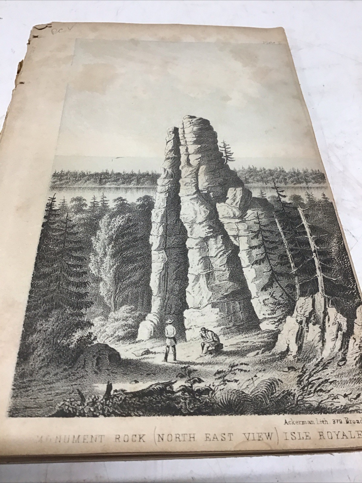
Rare 1851 Antique Lithograph Plate Volume Lake Superior Michigan Geology Pictured Rocks Mackinac Island Foster Whitney Ackerman📋 Item SpecificsFieldValueBindingDisbound / Loose Plates in Original Spine BlockSubjectExploration, History, Geology, PaleontologyTopicLake Superior, Michigan Upper Peninsula, Native American HistoryOriginAmericanYear Printed1851Special Attributes1st Edition, Illustrated, Rare Tint LithographsAuthorJohn Wells Foster & Josiah Dwight WhitneyPublisherU.S. House of Representatives / Printed by James AckermanLanguageEnglish📝 Detailed Item DescriptionTitle of Original Work:Report on the Geology and Topography of a Portion of the Lake Superior Land District in the State of Michigan: Part II (The Iron Region, Together with the General Geology) Authors:J. W. Foster and J. D. Whitney, U.S. Geologists Lithographer:James Ackerman, 379 Broadway, New York Date:1851 Format Size:Octavo (\(8^{\text{vo}}\)), approximately 5.75" x 8.78"OverviewUp for sale is an incredibly rare, authentic1851 mid-19th-century plate volume blockcomprising the original tint lithographs from the landmark U.S. government geological survey of the Michigan Upper Peninsula. This section contains the complete back-of-the-book run fromPlate 2 through Plate 35, bound together in its original string spine block, though completely detached from its text chapters and outer covers.[1,2]These prints are highly coveted by regional historians, antiquarian art dealers, and collectors of Great Lakes lore. They feature early, definitive panoramic views of famous geological formations, frontier settlements, early native interactions, mining schematics, and ancient fossils.Visual Highlight Breakdown - Scenic & Historic Landscapes:Includes highly desirable views such asMonument Rock on Isle Royale,Miners’ Castle(showing its original twin-turret profile before a 2006 collapse),The Grand Portal(the legendary natural archway that collapsed in 1900),The Chapel (View from East),Arched Rock on Mackinac Island, andThe Trap Rock River.
- Frontier History:Features the important“Boulders at Sault Ste. Marie”plate, capturing Native American wigwams, traditional canoes, and early log cabins on the shoreline.
- Industrial Mining & Metallurgical History:Technical, full-page industrial layout schematics detailing the structural blueprints and“Sections of an Iron-Forge”.
- Paleontology Section:Multi-pane large fold-out plates depicting ancient Devonian and Ordovician Paleozoic fossils, massive prehistoric cephalopod columns, and giant trilobites (Trenton Limestonelayers).
Printing Quality & ConditionThese plates utilize James Ackerman's uniquetwo-tone tint lithography method. Each page was pressed twice: once with fine black ink for geometric sharpness, and once with a tan/cream-tinted block for sky and water textures. - Condition Report:The collection is in solid, uncleaned antiquarian state. Mild, expected water staining and edge foxing are visible along some outer margins, typical for 1850s government field paper. The core visual areas remain exceptionally clean and crisp. The paper spine is exposed but securely holds the plate block together. Perfect for display as a rare intact volume or as a premium "breaker" set for framing.
💎 Rarity & Market Value Context - Historical Rarity:Highly Scarce.Mid-19th-century federal exploration records had small production numbers, routinely subject to decay over the last 175 years.
- The "Breaker" Factor:Complete runs of these plates are rare because art dealers frequently split the volumes to sell scenic highlights. Having Plates 2 through 35 intact in an un-split string block is highly uncommon.
- Estimated Value Assessment:Retailers specializing in historic prints commonly list individual scenic views (likeThe Grand PortalorMackinac) for$100 to $150 per plate. An intact run containing all landscape panoramas alongside industrial maps and fossils makes this block extremely appealing for collectors or regional antiquarian specialists.
Part 1: Scenic Landscapes & Landscapes (Images 1–4) - Plate 1:“Monument Rock (North East View) Isle Royale”— Landmark sea stack on Isle Royale.
- Plate 2:“The Castles”— Early view of the Pictured Rocks sandstone shoreline.
- Plate 3:“Mount Houghton, Lac La Belle”— Scenic overview of the Keweenaw Peninsula landscape.
- Plate 4:“Trap Rock River”— An early explorer fishing near a waterfall along the river.
Part 2: Pictured Rocks Sandstone Features (Images 6–10) - Plate 5:“Entrance to Grand Island Harbor”— A masted sailing vessel navigating past the massive sandstone cliffs.
- Plate 6:“Miners’ Castle, Pictured Rocks”— Famous rock formation showing its original "two turrets" intact (one collapsed in 2006).
- Plate 7:“The Amphitheatre, Pictured Rocks”— A sweeping, curved crescent of towering cliffs with a small sailboat at the base.
- Plate 8:(Untitled Profile View)— A side-profile perspective of the stratified cliff faces rising directly out of the lake water.
- Plate 9:“The Grand Portal, Pictured Rocks”— Massive natural stone archway over Lake Superior (collapsed completely in 1900).
Part 3: Famous Formations, Settlements, & Industrial Blueprints (Images 11–15) - Plate 10:“View of the Chapel from the East”— The famous Chapel Rock formation at Pictured Rocks.
- Plate 11:“Arched Rock – Mackinac”— The iconic limestone arch on Mackinac Island, viewed from the beach below.
- Plate 12:“Boulders at Sault Ste. Marie”— Landmark historical print showing glacial erratics, frontier log cabins, a Native American wigwam, and a traditional canoe.
- Plate 13:“Sections of an Iron-Forge”— A double-page technical schematic and architectural blueprint of an early iron-processing forge.
- Plate 14:(Geological Specimen/Fossil)— A fold-out scientific drawing of localized rock structures or trace fossils.
Part 4: Paleontology & Fossils (Images 16–20) - Plate 15:“Trenton Limestone (Plate XXIV)”— Fine technical illustration of fossilized bryozoans/ancient coral-like organisms.
- Plate 16:“Trenton Limestone (Trilobite)”— A dramatic, full-page illustration of a giant fossilizedIsotelustrilobite.
- Plate 17:(Multi-Pane Large Fold-Out Plate)— Long, folding panoramic drawing showing fossilized trackways (Climactichnites) or structural wave marks in prehistoric sandstone.
- Plate 18:(Fold-Out Cephalopod Plate)— Multi-pane drawing detailing the segmented internal chambers of prehistoric straight-shelled cephalopods.
- Plate 19:“Upper Helderberg Group”— Scientific grouping of Devonian-era brachiopod shells and coral fragments.
Keep in mind the shipping price also covers handling fees, packaging materials & time, not just postage.
See our store for thousands of our other items. B16
|
|
Other Related Items:
Related Items:
Rare 1851/2 Pre Civil War B&O Railroad Stock Certificate, Signed by Thomas Swann $14.99
EXTREMELY RARE 1851 STATE OF TEXAS Legal Deed Document, Law, Grayson, Black GIFT $155.00
Rare 1851 Book Of James Ackerman Lithographs #2-35 379 Broadway NY / 4 Pullouts $1200.00
|
